Mandi district — Varanasi of the Hills — 81 Temples & Prashar Lake

Mandi District — Varanasi of the Hills — 81 Temples & Prashar Lake

Himachal Pradesh · Mar–Jun, Sep–Nov · 760–4700 m altitude

Quick Facts Places to Visit Food Plan Trip

About Mandi

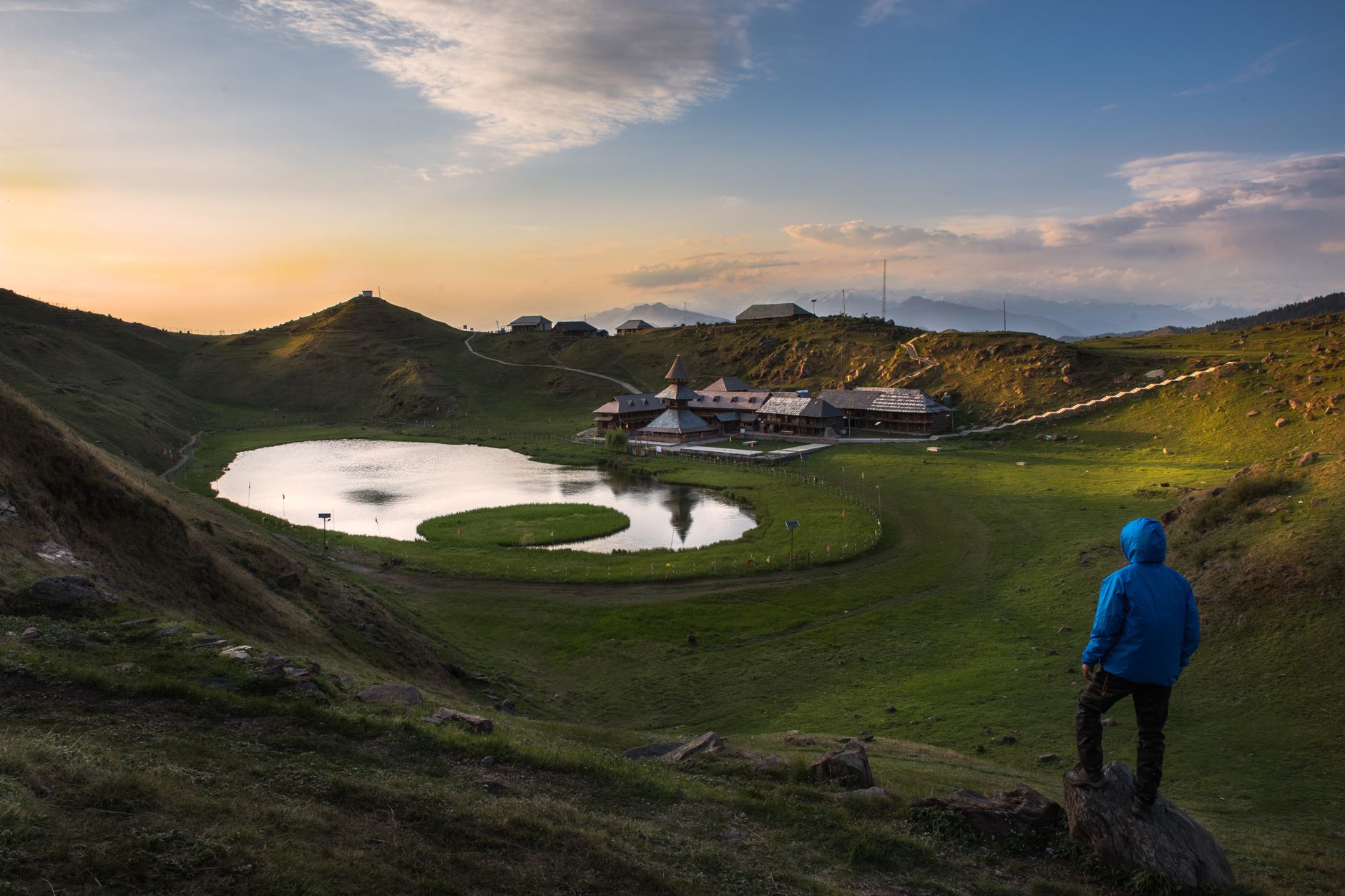
Mandi sits at the confluence of the Uhl and Beas rivers and is often described as the 'Varanasi of the Hills' for its 81 ancient temples. The Mandi Shivratri fair is one of Himachal's biggest festivals. Prashar Lake — a high-altitude lake with a 3-storey pagoda floating in it — ranks among the most mystical destinations in the state. Rewalsar Lake is sacred to Buddhists, Hindus and Sikhs alike.
Quick Facts

District HQ
Mandi
Area
3950 km²
Altitude
760–4700 m
Best Season
Mar–Jun, Sep–Nov
Summer Temp
20–38°C
Winter Temp
0–18°C
Nearest Airport
Bhuntar (Kullu-Manali) / Chandigarh
From Delhi
425 km

Top Places to Visit (10)

Prashar Lake

Prashar Lake

2,730 m7 km trek from Baggi village (or a rough road drive for 4WD vehicles) makes thcan be reached as a day trip from Mandi
  • Ringed by folded ridges at 2,730 m above the Beas valley, Prashar Lake is distinguished by one of Himachal's most unusual natural features: a floating reed island that drifts slowly across the lake surface over the seasons, its movement said by locals to be guided by the will of the sage Prashar.
  • The three-storey wooden pagoda temple on the lake shore, built in the 13th century without nails using the traditional Himachali interlocking joint technique, is a masterwork of regional architecture.
  • The 7 km trek from Baggi village (or a rough road drive for 4WD vehicles) makes thcan be reached as a day trip from Mandi.
  • Camping on the ridge above the lake under a sky dense with stars is a defining experience of the district.
Rewalsar Lake

Rewalsar Lake

1,360 m23 km south of Mandi
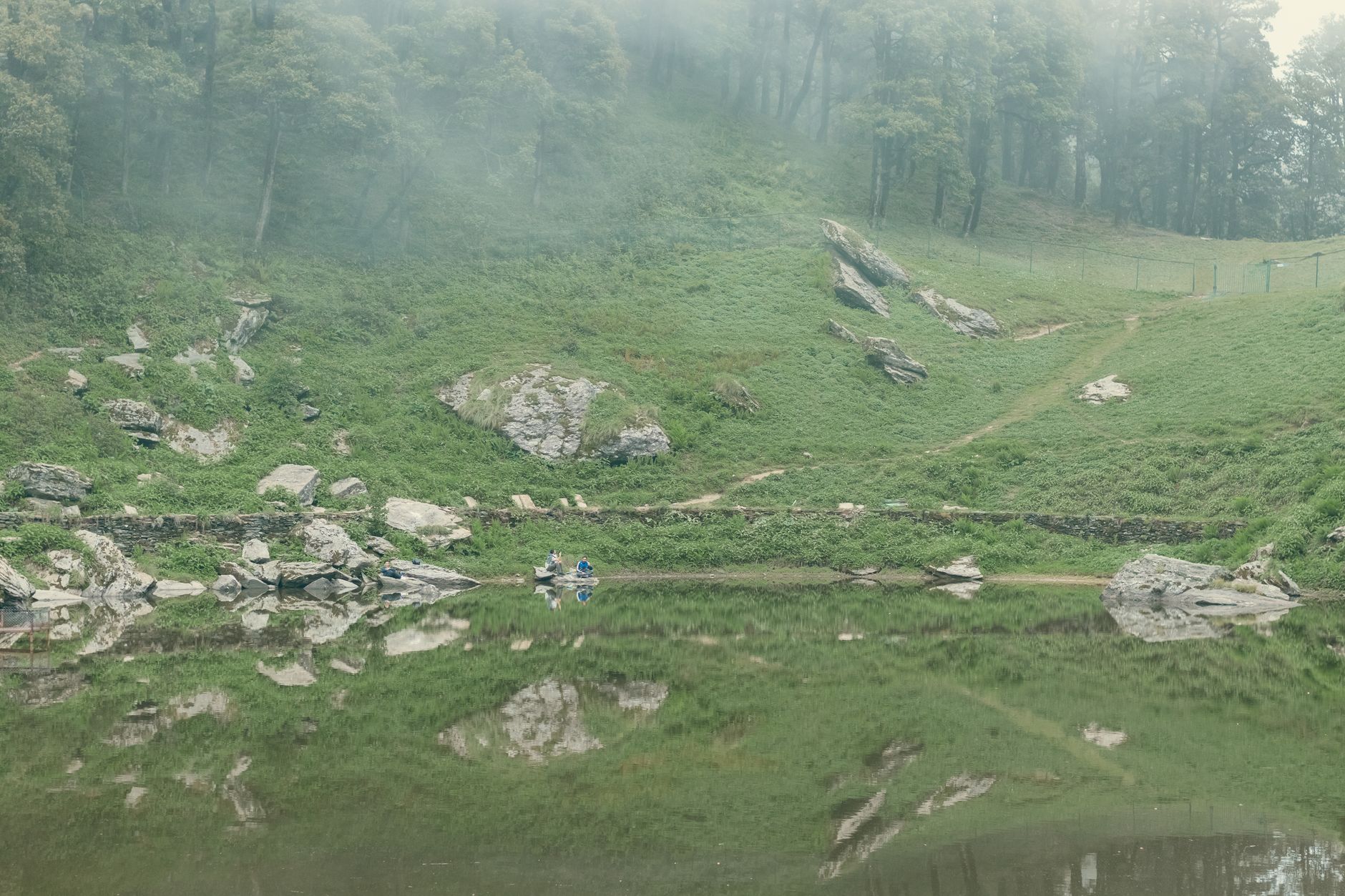
  • Compressed within the Shivalik hills south of Mandi at 1,360 m, Rewalsar ranks among the most spiritually complex sites in India — a single lake simultaneously sacred to three distinct religious traditions.
  • Buddhists revere it as the place where Guru Padmasambhava (Rinpoche), founder of Tibetan Buddhism, meditated before departing for Tibet in the 8th century; Hindus know it as the residence of the sage Lomas; and Sikhs associate it with Guru Gobind Singh, who camped here in 1705.
  • Local legend traces the lake's origin to a king's daughter who chose religious devotion over marriage: when her furious father tried to punish her and burn the monk who taught her, the execution site is said to have transformed overnight into this lake, with a lotus flower rising at its centre — which is why Tibetan Buddhists call Rewalsar 'Tso Pema', the Lotus Lake.
  • Three monasteries (Tibetan Buddhist), a gurudwara, and several Hindu temples ring the lake shore.
  • The floating reed islands on the lake surface — locally believed to have broken off the shore and drifted permanently — are analogous to those at Prashar, and are themselves part of the lake's mystique.
  • Rewalsar is reached by a good road 23 km south of Mandi.

Mandi Town

760 m
  • Seated at the confluence of the Uhl and Beas rivers at 760 m, Mandi is often described as the 'Varanasi of the Hills' — a title earned by the extraordinary density of temples in and around the old city: over 81 ancient stone temples, many dating to the 16th–18th century Sena dynasty, are documented within the town and its immediate surroundings.
  • The ghats on the Beas, the Trilokinath temple (17th century), and the series of temples along the old bazaar lanes create a genuinely devotional townscape.
  • The Mandi Shivratri fair (February–March) brings over 200 gods from surrounding villages to the Chaugan maidan in palanquins for a week of processions, music and commerce — one of Himachal's most significant cultural events.
  • The Raj Mahal palace (1925) on the riverside is now a heritage hotel.
Shikari Devi

Shikari Devi

3,359 m
  • The Shikari Devi temple at 3,359 m is one of Himachal Pradesh's most dramatic open-air shrines — a roofless platform of ancient stonework on a forested summit where the goddess has refused, according to legend, to allow a roof to be built: every attempt has been destroyed by lightning.
  • The temple is reached by a 3–4 hour trek through dense deodar forest from Khanag village, or by a rough road passable in summer.
  • In winter (December–February) the approach trail is under 2–3 m of snow and the temple is completely buried; pilgrims then descend and perform puja at the treeline.
  • The summThis place is on a major migratory bird flyway and is outstanding for raptor watching in September–October.

Barot Valley

1,800 m53 km tunnel to carry the Uhl's water to powerhouses in the Kangra Valley
  • The valley of the Uhl river at Barot village (1,800 m) was shaped by the Shanan hydroelectric project of 1932 — the oldest major hydroelectric installation in India still in operation, built by the British using a 53 km tunnel to carry the Uhl's water to powerhouses in the Kangra Valley.
  • The British-era bungalows, stone bridges and the spillway infrastructure give Barot a curiously timeless quality.
  • The Uhl river is one of Himachal's premier brown trout fisheries (Forest Department permits available in Barot).
  • Camping in the pine forest above the river and the walk to the Barot Lake through rhododendron forest are the main activities.
  • The valley connects via the Jalori Pass area to the Tirthan Valley and Kullu district.

Jogindernagar

165 km
  • The western terminus of the Kangra Valley Railway — the narrow-gauge 'toy train' line built between 1926 and 1929 that links Pathankot to this small town through the Kangra Valley — Jogindernagar is primarily a functional base for the Shanan hydro project whose penstocks descend from the Barot tunnel.
  • The Uhl river below town offers river rafting, and the Ravi river confluence zone to the north has good bird habitat.
  • The Kangra Valley Railway journey from Pathankot (165 km, 8–9 hours) is one of the great scenic railway experiences of India, passing through rice paddies, tea gardens, bamboo groves and small-town markets on a line that UNESCO has recognised as part of India's mountain railway heritage.
Sundernagar

Sundernagar

1,155 m
  • The largest sub-divisional town of Mandi district, Sundernagar at 1,155 m on the Satluj sits above the Sukh Sagar Lake — a reservoir of the Beas-Satluj Link Project that has created a significant water body in the Mandi lowlands.
  • The town has a college, a government hospital and a busy market, and serves as the practical hub for lower Mandi district travel.
  • The Shri Naina Devi temple complex on the ridge above the lake offers panoramic views.
  • Sundernagar is the junction town for travellers entering Mandi from Chandigarh on the NH3 — the faster Beas river valley route to Manali passes through here.
  • The Sukh Sagar lake shore now includes with gardens and a boating facility.
Kamlah Fort

Kamlah Fort

4 km from Mandi town is a scenic if fragmentary heritage site — its stone walls
  • The ruined fort of the former Sukhet kingdom on a rocky hillock 4 km from Mandi town is a scenic if fragmentary heritage site — its stone walls, gateways and water cisterns now largely reclaimed by grass and wild fig trees.
  • The Sukhet kingdom was an independent polity that controlled central Mandi before being absorbed by the Mandi rajas in the 18th century.
  • The fort views over the Beas valley and toward the Dhauladhar are excellent.
  • A small temple on the summit ridge is still active.
  • The climb from the base village takes approximately 45 minutes on a rough trail through scrub forest.

Pandoh Dam

15 km south of Kullu town
  • The Pandoh Dam on the Beas river, 15 km south of Kullu town, is the intake structure of the Beas-Satluj Link Project — a major engineering achievement that diverts Beas water through a 38 km tunnel under the Dhauladhar to the Satluj at Sundernagar.
  • The reservoir created behind the dam fills a narrow gorge with exceptionally clear green water, flanked by near-vertical cliff faces.
  • A viewpoint and picnic area on the dam top attracts local visitors.
  • The road on the south bank of the reservoir, bypassed by the main NH3 highway, is a scenic alternative with fine views of the water in the gorge.
  • The dam has eliminated the spring floods that historically devastated the lower Beas valley.

Karsog

1,400 m40 km detour from the main highway
  • Hidden in a broad sub-valley of the Satluj system south of the main Mandi-Shimla highway, Karsog at 1,400 m is one of the least-visited valley settlements in Mandi district — a landscape of terraced rice fields, apple orchards and deodar forest with a distinctly traditional Himachali character.
  • The Mahunag temple fair (July–August) is one of the district's most important local festivals, drawing devotees from surrounding villages who walk for hours through the forest.
  • The apple harvest (September–October) is the best time to visit; the orchards around Karsog produce a unique 'Karsog apple' variety prized for its flavour.
  • A handful of basic guesthouses and homestays accommodate the occasional traveller who takes the 40 km detour from the main highway.

Local Food & Cuisine

Dham (traditional feast)Patande (sweet pancake)MadraSidduMitha

Famous For

81 TemplesShivratri FestivalPrashar LakeRewalsar (tri-faith pilgrimage)

Plan Your Mandi Trip

Talk to our local experts. Best packages, handpicked hotels, private cabs.

WhatsApp Us — Free Itinerary

Mandi Travel Guide: Places to Visit, Routes & Itinerary

Planning a trip to Mandi in Himachal Pradesh? Use this guide to discover tourist places, practical routes, sightseeing ideas and itinerary options. Himachal Explorer connects destination information with road-route planning so you can compare places and build a realistic day-wise trip.

For visitors searching for mandi himachal tourist places, prashar lake, rewalsar and barot valley, this page brings together the key locations and travel-planning information in one place. You can also explore the Himachal tourist places map, compare Himachal tour packages, or use the Himachal trip planner to create a custom route.